Back to the Space Place Index
Hurricane Team Work
by
Dr. Tony Phillips
On a gray breezy day last month thousands of people got in their cars
and reluctantly left home. U.S. east coast highways were thick
with traffic. Schools were closed. Businesses shut down.
Perfect!
When powerful Hurricane Isabel arrived some 38 hours later nearly
everyone in the storm's path had fled to safety.
Days later Vice Admiral Lautenbacher, in a briefing to President Bush,
praised the National Atmospheric and Oceanic Administration (NOAA):
"Without NOAA's excellent track forecasts, hurricane Isabel's
toll on lives and property would have been even more devastating. This
is NOAA's first year of providing 5-day forecasts-and the 5-day
forecast for Isabel was as good as our 2-day forecasts have been over
the last decade."
Many people in NOAA played a role. A team of pilots, for
instance, flew Gulfstream-IV High Altitude Surveillance jets right up
to the approaching hurricane, logging 25,000 miles in the days before
landfall. Their jets deployed devices called dropsondes-little
weather stations that fall toward the sea, measuring pressure,
humidity, temperature and wind velocity as they plummet. The
data were radioed back to the aircraft and transmitted to forecasters
on shore.
While two Gulfstream-IV crews flew night and day around the storm, a
NOAA satellite named GOES-EAST monitored Isabel from above.
(GOES is short for Geostationary Operational Environmental
Satellite.)
From an orbit 22,300 miles above the Atlantic Ocean, GOES-EAST had a
unique view. "It could see the entire hurricane at once,"
says Ron Gird of NOAA. "Scientists used infrared spectrometers
onboard the satellite to estimate the height of the storm clouds,
their temperature and water content. GOES can also measure the
temperature of the ocean surface-the source of power for
hurricanes."
Constant streams of data from GOES and the Gulfstream aircraft were
fed to supercomputers at NOAA's Environmental Modeling Center in
Maryland where sophisticated programs, developed over the years by
meteorologists and programmers, calculated the storm's most likely
path.
Supercomputers. Satellites. Jet airplanes. Scientists.
Programmers. Pilots. It took a big team using a lot of tools to
predict where Isabel would go-accurately and with time to spare.
Says Vice Admiral Lautenbacher: "I hope everyone at NOAA shares the
pride of being part of a team effort that so effectively warned the
public of impending danger and enabled citizens to take action to
protect themselves and their loved ones."
Well done, indeed.
To learn more about the GOES, see www.oso.noaa.gov/goes/ .
For kids, the SciJinks Weather Laboratory at scijinks.nasa.gov has
lots of fun activities and fascinating facts about the wild world of
weather.
This
article was provided by the Jet Propulsion Laboratory, California
Institute of Technology, under a contract with the National
Aeronautics and Space Administration.
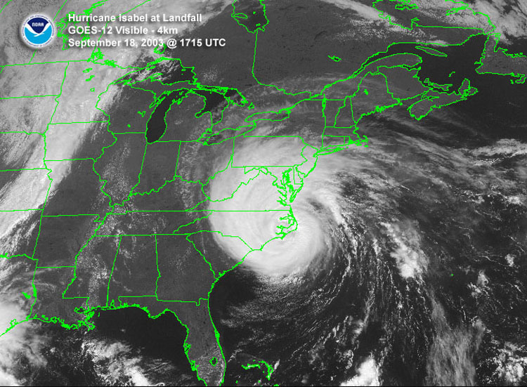
GOES-East satellite image of hurricane Isabel as it makes landfall
on September 18, 2003 at 1715 UTC.
|
About LUNAR |
Home |
Calendar |
Contacts |
Old Gallery |
Member Pages |
Events |
Presentations & Docs |
LUNAR'clips |
Handbook |
Space Place |
Mailing Lists |
Joining |
Other Rocketry Pages |
Site Map |
Frames |
All content is the responsibility of LUNAR.
If you have comments or suggestions regarding these web pages,
please contact the 
Copyright © 1992 - 2026 LUNAR